What are the deadliest, costliest, and strongest ever typhoons that directly hit the province of Cebu? How does Typhoon Rai fit into the list?
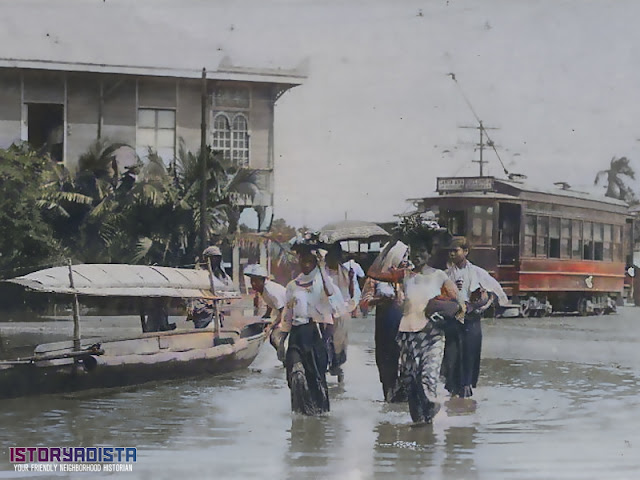
Editor’s Note: This is an updated post in response to my old article of a similar title. However, this article will focus more on the deadliest,
costliest, and strongest ever typhoons that directly hit the province of Cebu.
As of writing, Cebu and other affected provinces in the country are picking up
the pieces to rebuild to become more resilient in time for the next big one.
So how does Typhoon Rai (Odette) fit in with the worst typhoons to ever hit the
island?
We all know by now that the Philippines is the usual path of most
tropical typhoons in the Pacific region. Every year, it costs a lot of lives
and property damage to everyone living on its path. With climate change virtually
affecting weather and other meteorological phenomena, it is expected that
typhoons have become stronger than ever before. When these
strong winds have reached mythic proportions similar to the 1881 typhoon that
killed 20,000 people (considered as the deadliest typhoon in the Philippines, even
far worse than Typhoon Haiyan (Yolanda) that killed 6,300 people) or the 1975
Typhoon Nina (Bebeng) that also triggered the Banqiao Dam collapse in China
that eventually caused the death of 229,000 people, we may think that these are rare historical freaks of nature. That's no longer true anymore.
According to Time Magazine, we live in the "most exposed country in the
world to tropical storms." Known locally as 'bagyo,' about 20 tropical cyclones
enter the Philippine area of responsibility annually while about half of them are
expected to become typhoons with half of them having the potential to become even
more destructive super typhoons. If you come to think of it, you may think that our country can be considered as a 'typhoon alley' similar to the 'tornado alley' designation of the great plains of the central United States (Texas, Louisiana, Arkansas, Oklahoma, Kansas, South Dakota, Iowa and Nebraska).
Early Historical Accounts
There’s not a lot of reliable and clear scientific data on the typhoons that hit the island of Cebu during the Spanish colonial period. However, the work of Jesuit priest and astronomer Fray Miguel Selga (1879-1956) gave us a glimpse as to how the typhoons in the past have affected Cebu during that time. Bear in mind that the typhoons were not yet named.
 |
| The typhoon that hit the Nao Capitana is perhaps one of the earliest accounts of a typhoon that hit the country |
In June 1568, Spanish conquistador Felipe de Salcedo left Cebu on the Nao Capitana bound for Nueva España (modern-day Mexico). With his boat-load of cinnamon and over 130 men, they left the island under favorable weather but later encountered a storm on August 15 where it destroyed its ship and all its precious cargo. It’s not known if it eventually made its way to Cebu.
A very strong typhoon hit Cebu, Siquijor, and southern Negros on June 24, 1753, is perhaps the earliest typhoon ever recorded to hit the island. By the 18th and 19th centuries, more descriptions were made and meteorological and astronomical data have become available with the establishment of the Observatorio Meteorológico de Manila in 1865.
Reports noted about the effects of typhoons include terms like 'piedra rota la delantera' (stone removed, washed out), 'hierro galvanizado remangzado' (galvanized roof torn off), 'el balconage roto' (balcony destroyed), 'piedra destrosada' (stone destroyed), 'hierro galvanizada tombada y destrosada' (galvanized roof turned over and destroyed).
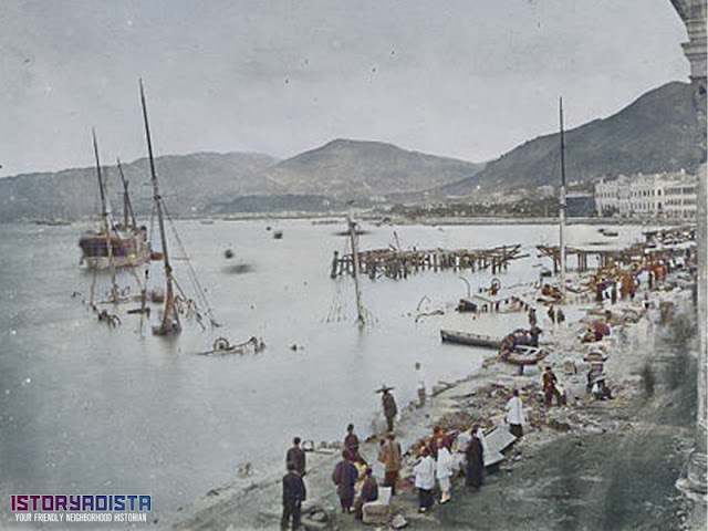 |
| The damages to properties and infrastructures brought by the 1874 typhoon is similar to what had happened here in Hong Kong |
There is a very fascinating account about a particular typhoon that hit the province on December 25, 1874, as a violent tropical typhoon came howling over Cagayan de Misamis and northern Mindanao where it is said to have ‘uprooted’ a stone church and mortar buildings. By the time it reached Cebu on the afternoon of December 26, fierce gusts from the west have lasted for six hours and destroyed a lot of houses made from light materials. Trees were waylaid and the rivers overflooded their banks. Small fishing boats and cascos were sunk in the bay. It is said that the naval destroyer Callao run aground at the back of the church with strong winds and big waves destroyed the stone landing.
From November 25 to 27, 1876, a super typhoon, considered the strongest in 20 years prior, unleashed its fury as brought about death and desolation in the Visayas and Mindanao. Alongside Cebu, Bohol, Panay, Negros, northern Mindanao, Palawan, and the Calamianes group of islands were the hardest hit. About 150 people were killed and countless livestock was lost. Coastal embankments were engulfed while a great number of churches, schools, houses, and bridges were blown away by terrifying gusts of wind.
It is interesting to note that during that decade from 1866 to 1876, an unusual string of super-strong typhoons has ravaged most of Visayas and Mindanao. A rare occurrence happened in December 1879 as two typhoons passed by Cebu on December 11-16 and December 22-26.
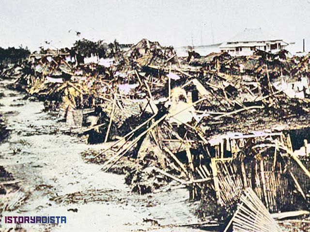 |
| Most houses are made from light materials so they were destroyed like a deck of cards as seen on the impact of the 1882 typhoon that hit Luzon |
On November 26-28, 1881, a typhoon appeared on eastern Mindanao, crossed Surigao, and then moved west-northwest through Bohol, Cebu, Negros, Panay, Cuyo and northern Palawan where it continued to the China Sea towards French Indochina (modern-day Vietnam). The "Haiphong" Typhoon is considered the deadliest typhoon in Philippine history as it killed over 20,000 people.
Two years later, a similar typhoon appeared on eastern Mindanao on April 24, 1883, where it moved west-northwest through Surigao, northern Cebu, Capiz, and Mindoro then eventually reached Swatow (now Shantou) in China. A small but deep typhoon occurred on April 23-28, 1885 where it crossed from Siargao and Dinagat Islands to the west by north through Cebu, Negros, Panay, and northern Palawan towards the South China Sea.
Pre-War Typhoons
By the time the Americans took over the country, they have established a new way of typhoon tracking and weather forecasting. On May 22, 1901, the Observatorio Meteorológico de Manila was reorganized and placed under the Weather Bureau of the Department of Interior.
The Capiz Typhoon of June 1-8, 1903, was remarkable for its small diameter, high velocity and intensity. It was so small that no one suspected its passage or predict its approach. It started a short distance to eastern Mindanao then it passed northern Surigao by moving west-northwest. It crossed close to central Leyte and swept across the extreme northern part of Cebu and the whole of northern Panay in a direction parallel to the coast.
Two typhoons hit Cebu in 1909. The first one was on November 3-8 that formed around southeast Yap Island where it moved west by north between Yap and Palau towards northern Mindanao. It continued across Surigao, Bohol, Cebu and Negros, developing as it moved into the China Sea. The second one was on December 15-21 that formed in the south of the Western Carolines where it moved westward. It inclined towards the north and recurved east of the Visayas towards the Pacific. A secondary center entered Mindanao, passed over Butuan, crossed Bohol and Cebu and filled up over Negros. Strong winds and heavy rains were experienced at Baganga, Butuan, Garcia Hernandez, Duero and Cebu.
 |
| The typhoon caused great damage and deaths that it was even reported in American and foreign newspapers |
1912 saw two destructive typhoons that hit Cebu and its neighbors. On October 14, a typhoon appeared 300 miles off eastern Leyte and then moved west and changed to the northwest towards Cebu and left the country through Mindoro. Both Cebu and Leyte suffered great destruction to life and property. Over 15,000 people have died from it, mostly in Leyte and Capiz.
With the establishment of the Department of Agriculture and Natural Resources (DANR) on January 1, 1917, the Weather Bureau was transferred from the Department of Interior to DANR.
On October 10-20, 1919, a typhoon formed in the Pacific Ocean which then moved due west across Leyte, Cebu, Negros, Panay, and Palawan. It then inclined to the north in the South China Sea and entered French Indochina south of Tourane (now, Da Nang, Vietnam). Great damage was caused by the rains and floods.
The Manila Typhoon of May 16-26, 1926, that originated in the Pacific off the southeastern part of Mindanao passed hit Surigao, northern Cebu, Sibuyan, Marinduque, and Manila. It then changed direction to northwest by west towards the South China Sea south of Iba, Zambales and then hit Hainan, China.
On January 2-5, 1931, a typhoon crossed Leyte, Camotes Islands, northern Cebu, northern Negros, central Panay and passed into the China Sea between Mindoro and Busuanga. Wind velocity at Cebu reached the rate of 118.7 kph. Total damage in the Philippines was estimated at no less than six million pesos. The National Headquarters of the American Red Cross donated P20,000 while the local chapter spent 15,000 in relief work. Governor-General Dwight Davis issued Proclamation No. 357 on January 23, 1931, asking all citizens to lend all possible aid to a special Typhoon Fund.
 |
| Things never changed. A 1931 Free Press editorial cartoon showing the need for better flood protection. |
With the establishment of the Commonwealth of the Philippines in 1935, the DANR was reorganized into the Department of Agriculture and Commerce. And so goes the Weather Bureau.
Post-War Typhoons
There was not a lot of typhoons that were monitored or recorded to have hit Cebu during World War II. Not a lot of significant typhoons and super typhoons have hit the island until Typhoon Amy on December 3-17, 1951.
Typhoon Amy (1951)
The typhoon started as an area of low pressure near the Kwajalein Atoll on December 3 until it developed into a tropical cyclone. Tracking in a general westward direction, the storm quickly intensified to reach typhoon intensity the next day. It was able to intensify to reach its peak intensity with maximum sustained winds of 220 kph (140 mph) and a minimum barometric pressure of 950 mbar on December 8. Over the ensuing two days, it moved over several islands in the central Philippines before emerging in the South China Sea on December 11 as the equivalent of a minimal typhoon.
 |
| Typhoon Amy coincided with the 1951 Mount Hibok Hibok eruption in Camiguin |
Typhoon Amy was considered one of the worst typhoons to strike the island on record. What made it even worse was that it occurred during the eruption of Mount Hibok-Hibok in Camiguin. Cebu City suffered the worst impacts as most of the city's buildings were heavily damaged and 29 people died in the city. Strong winds and rainfall in the city associated with the typhoon also set records that still remain unbroken today. Damage was estimated at ₱560 million.
Overall, Amy caused $30 million in damage and at least 556 fatalities, though the final death toll may have been as high as 991, making the typhoon one of the deadliest in modern Philippine history. An additional 50,000 people were displaced by the storm.
 |
| Typhoon Amy is perhaps the most devastating typhoon that hit Cebu prior to Typhoon Mike (Ruping) and Typhoon Rai (Odette) |
In the aftermath of Typhoon Amy, President Elpidio Quirino declared a state of public calamity for eleven central provinces including the island of Camiguin, which was heavily affected by both the typhoon and Mount Hibok-Hibok. On December 24, the American Red Cross granted $25,000 to the Philippine Red Cross.
Typhoon Lucy (1962)
Tropical Depression 86 near Koror on November 25, 1962, has strengthened into Tropical Storm Lucy on the same day. Strengthening occurred slowly, as Lucy did not gain typhoon status until November 27. That same day, Lucy made landfall in the Philippines as a 130 kph (80 mph) typhoon. It kept moving west and peaked at 185 kph (115 mph), as a Category 3 typhoon on November 29. Lucy made landfall in the Philippines and southern South Vietnam on November 30. Lucy dissipated in the Strait of Taiwan on December 1 from cold air and land interaction.
Five people were killed, with $5 million (estimated $46 million in 2021). Winds of 97 kph (60 mph) were felt at Cebu City Airport when Lucy passed over the area.
In 1963, the Weather Bureau (later Philippine Atmospheric, Geophysical and Astronomical Services Administration or PAGASA) have started giving local names to the tropical depressions that enter or form in the Philippine area of responsibility.
Typhoon Louise-Marge (1964)
Louise–Marge (Ining-Liling) began as a cyclonic vortex associated with a tropical wave near Yap on November 12. Two days later, the system became a tropical depression and reached tropical storm intensity on November 15. This initial tropical cyclone was named Louise and it became a typhoon the next day. Louise continued to intensify after passing the island and attained its peak intensity on November 18 with one-minute sustained winds of 305 kph (190 mph) and central air pressure of 915 hPa.
On November 19, Louise made landfall on Lanzua Bay in Surigao del Sur, with winds of approximately 260 kph (160 mph). A second distinct tropical cyclone east of the Philippines, named Marge, formed concurrently. Marge is seen as a continuation of Louise. This storm tracked across Luzon and eventually dissipated in the South China Sea by November 26.
The U.S. Weather Bureau called Louise-Marge one of the most destructive storms ever documented in the central Philippines. At least 576 people were killed, though the Philippine Red Cross recorded 631 fatalities, along with 157 missing people and 376,235 people displaced by the typhoon. Nineteen Philippine provinces were impacted by the storm.
Although it passed through central Cebu, widespread destruction occurred in Surigao City where the storm killed 312 people and caused $12.5 million (estimated $112 million in 2021) in damage. Several ships sank during the storm, contributing in part to the death toll. A state of calamity was declared for Surigao del Norte, prompting an intense relief effort amid an ongoing cholera epidemic and unrelated flooding.
In June 1966, the Congress of the Philippines authorized P3.4 million to be distributed annually through the fiscal year 1969-70 for the province and its municipalities.
Typhoon Ike (1984)
Also known as Typhoon Nitang, Ike is the second deadliest tropical cyclone in the 20th century in the Philippines. It originated from an area of disturbed weather southeast of Guam on August 21, 1984, and five days later, developed into a tropical depression.
Following an increase in organization, the depression attained tropical storm intensity on August 27. Initially tracking west-southwest, the storm gradually gained strength as wind shear resulted relaxed and Ike became a typhoon on August 30.
 |
| President Ferdinand Marcos surveying the damage brought about by Typhoon Ike |
Continuing to rapidly intensity, Ike turned west and attained peak intensity on September 1 with estimated winds of 170 kph (105 mph). It made landfall on the northeastern tip of Mindanao. The cyclone emerged into the South China Sea on September 3 as a tropical storm before re-intensifying into a typhoon and moving onshore Hainan and struck the Chinese mainland as a tropical storm, It dissipated on September 6.
In Cebu, many refugees stayed in town halls and churches during the storm. Strong winds snapped power lines resulting in a power outage that impacted the entire province and halted all radio broadcasts. Off Cebu City, 10 ferries sunk due to the strong waves generated by Ike. Roads connecting Cebu City to 44 peripheral towns were blocked by fallen trees and severe flooding. Throughout the province, 90,000 people were left homeless and damage totalled at least $6.8 million (estimated $18 million in 2021).
All in all, 1,426 people were killed as a result of the typhoon, surpassing the previous record of Typhoon Amy in 1951. A total of 1,856 people were hurt. Furthermore, 108,219 houses were destroyed while an additional 142,653 homes were damaged. In all, the total damage was estimated at $230 million (estimated $615 million in 2021). Crop damage was placed at $76.5 million (estimated $204 million in 2021), with damage to coconut plantations totalling $61 million (estimated $163 million in 2021). Property damage on the islands reached $111 million (estimated $296 million in 2021).
Typhoon Agnes (1984)
Still reeling from the devastation brought by Typhoon Ike, an area of disturbed weather developed near the equator and the Caroline Islands on October 28. The cyclone was eventually designated a tropical storm on October 31. After tracking northwest initially, it turned west-northwest the next day, a course that the system would maintain for the rest of its lifetime.
It intensified into a typhoon on November 2, and on November 4, attained peak intensity. Typhoon Agnes (Undang) then made landfall on Samar. Although it weakened over land, it later re-intensified. In Cebu, six people died. There were 38 children who died aboard a ferry boat after it sank, though the adults on the boat swam to safety.
 |
| People were still reeling from the aftermath of Typhoon Ike |
Overall, 895 people perished with 272 people reported missing and 2,526 others hurt. There were 491,968 people evacuated to shelter in 27 provinces, most of whom were homeless. In all, 201,014 homes were destroyed, which led to roughly 600,000 people losing their homes. Furthermore, 163,056 homes were damaged.
Damage was estimated at $90.7 million (estimated $242 million in 2021), with $19.1 million (estimated $51 million in 2021) from crops, $56.9 million (estimated $152 million in 2021) from public infrastructure, and $14.8 million (estimated $39 million in 2021) from private infrastructure. It was the first time in living memory that the Philippines was deluged with three catastrophic storms.
Typhoon Mike (1990)
Known as Typhoon Ruping in the Philippines, it was the strongest typhoon to hit the country since Typhoon Irma (Anding) in 1981. Mike started from an area of persistent convection over the Caroline Islands, it was first designated on November 6, 1990, and moved generally westward. Later that day, the depression strengthened to a tropical storm near Yap.
It became a typhoon early on November 9, and subsequently entered a period of rapid deepening. Late on November 10, the typhoon reached its maximum intensity of 185 kph (115 mph). After weakening slightly, it made landfall in the central Philippines. The storm weakened considerably due to land interaction, only to briefly re-intensify on November 14. It reached the Gulf of Tonkin and passed over Northern Vietnam and southern China, where it dissipated on November 18.
There were 88 ships that were lost, the most ships ever sunk at the Cebu City harbor during a tropical cyclone. Power and phone lines were downed and the city lost access to drinking water for two days. Approximately 60% of all buildings were demolished and 28 people perished in the city.
Nationwide, 748 people were killed while 1,274 others suffered injuries. A total of 630,885 homes were damaged and 222,026 houses were demolished, resulting in 1,110,020 people being displaced. Offshore, 159 vessels sunk and 28 others were washed aground and damaged. Monetary damage was estimated at $446 million (estimated $910 million in 2021), including $46.1 million (estimated $94 million in 2021) from crops, $350 million (estimated $714 million in 2021) from public infrastructure, and $49.9 million (estimated $101 million in 2021) from private infrastructure.
Typhoon Haiyan (2013)
Known in the Philippines as Typhoon Yolanda, Haiyan was one of the most powerful tropical cyclones ever recorded. It is one of the deadliest Philippine typhoons on record, killing at least 6,300 people in that country alone. Haiyan is tied with Meranti in 2016 for being the second strongest landfalling tropical cyclone on record only behind Typhoon Goni (Rolly) of 2020.
 |
| Haiyan is the deadliest Philippine typhoon in modern history |
It caused catastrophic damage throughout much of Leyte, where cities and towns were largely destroyed. The National Disaster Risk Reduction and Management Council (NDRRMC) confirmed 6,300 fatalities across the country, 5,902 of those taking place in the Eastern Visayas. However, the true death toll remains unclear.
In Cebu and Bohol, struck by a magnitude 7.2 earthquake two weeks before, cities were also severely devastated. Widespread power interruptions, landslides, and flash floods were also reported. Major roads were blocked by trees, and impassable while 453 domestic and international airline flights were cancelled. The total damages were estimated at $2.2 billion (estimated $2.6 billion in 2021).
Typhoon Rai (2021)
This powerful and catastrophic tropical cyclone, also known as Typhoon Odette, became the first Category 5-equivalent super typhoon to develop in the month of December since Nock-ten in 2016, and the third Category 5 super typhoon recorded in the South China Sea, following Pamela in 1954 and Rammasun in 2014. It originated from a tropical disturbance near the equator on December 10, forming near the site of another low-pressure area that had dissipated on the previous day. Conditions around the system were favorable for further development, and it slowly developed into a tropical depression on December 12.
Further intensification ensued, and Rai was upgraded to a tropical storm the next day, before passing south of Ngulu Atoll. After passing near Palau and impacting the island nation, Rai entered the Philippine Area of Responsibility (PAR) by the night of December 14. While approaching the Philippines, Rai unexpectedly rapidly intensified into a Category 5 super typhoon just before its first landfall across Siargao. It then slowly but steadily weakened as it traversed the Visayas, exiting into the Sulu Sea. After making its last landfall over Palawan, Rai continued to weaken before unexpectedly re-intensifying into a Category 5-equivalent typhoon by December 18, while nearing Vietnam. On the next day, Rai entered yet another weakening phase, dissipating on December 22, southeast of Hong Kong.
 |
| Trees have fallen down after Rai ravaged the Visayas and Mindanao |
As Rai pounded the Philippines, heavy rainfall, strong and gusty winds impacted several areas around the storm's path. Many areas across the Visayas and Mindanao lost electricity with several provinces and areas being deprived further of communication services. Downed trees obstructed many roadways, and flooding was a major problem across the affected regions, particularly Bohol, where the storm was described as "one of the worst for the province".
Rivers also overflowed across Cagayan de Oro, while numerous buildings sustained damages. Surigao City was reported to be completely damaged and appealed for aid. Bohol also pleaded for help from the government due to the damages Rai brought to the area. A state of calamity has been placed in the province and Cebu. So far, 406 people have died, a large portion of which were from the severely affected island of Bohol.
Damages at the aforementioned location were projected to be worth $100 million, with those in Siargao being estimated to be worth $401 million and those in Negros Occidental being estimated to be worth $118 million. About 13 million people are expected to be affected in the Philippines.
The Worst of the Worst
Determining the worst of the worst typhoons that ever hit Cebu is no easy feat. The data gathered by the weather bureau and other relevant agencies are not complete especially with the typhoons that hit the country before reliable records were gathered. It would be fair to only compare the typhoons that only directly and indirectly hit the province one way or the other. Moreover, it's not easy to break down data that focus on Cebu alone.
The Deadliest
The primary criteria for determining the worst typhoon on record is the total death toll is caused. The 1881 "Haiphong" Typhoon is the deadliest on record but it is impossible to independently verify the number, let alone determine how many were from Cebu. Typhoon Haiyan is the deadliest one in modern times.

When it comes to the death toll in Cebu, Typhoon Rai is considered the deadliest typhoon with 96 deaths as compared to Typhoon Mike with 28 deaths.
If you compare it with the general population of the time, 0.3% of the population were lost during the deadly 1881 typhoon as the country has a population of 6.5 million. Comparatively, 0.002% of Cebu's population were lost to Typhoon Rai while 0.0015% were lost to Typhoon Mike.
The Costliest
Another determining factor to the worst typhoon on record is the total cost of damages brought to personal property and infrastructure. Without a doubt, Typhoon Haiyan is the most destructive typhoon on record with damages costing over $2.2 billion.
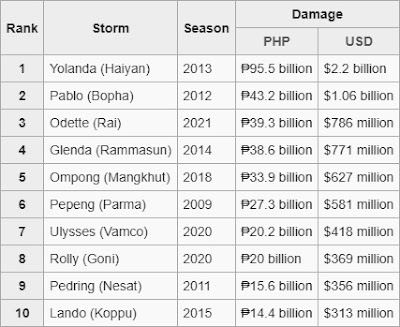
Since the figures are from the year when these typhoons occurred, it has to be adjusted for inflation to reflect the 2021 valuation. Since Typhoon Haiyan has the bulk of the damages that occurred in Leyte and Samar, Typhoon Mike may have been the costliest typhoon to hit Cebu with damages amounting to $952 million (adjusted to 2021) as compared to Typhoon Rai with $786 million. Typhoon Ike has damages costing $615 million (adjusted to 2021).
The Strongest
Without a doubt, Typhoon Haiyan is the strongest typhoon on record as it registered a wind strength of 230 kph (145 mph) to 315 kph (195 mph). As for actual recorded wind speed, Typhoon Durian registered 320 kph on Virac.

As far as Cebu is concerned, Typhoon Amy and Typhoon Louise both registered the highest wind strength at 240 kph while Typhoon Mike registered 220 kph.
Final Thoughts
Based on the gathered data (albeit limited), Typhoon Rai is perhaps the deadliest and costliest typhoon that ever hit Cebu. Typhoon Mike comes second place. Regardless of what the data says, tropical typhoons have always cost lives and property whether we like it or not. It's important for ordinary citizens and government officials alike to work together and prepare to mitigate the effects of these deadly natural disasters.
Sources:
“Everything You've Always Wanted to Know About Typhoons”. FILIPINO HERITAGE: The Making of a Nation by Lahing Pilipino Publishing Inc., 1977.
“Worst Typhoons of the Philippines (Spanish Period / 1617-1876),” by Dominic Alojado
“The Twelve Worst Typhoons of the Philippines (1947-2009),” by David Michael Padua
“Typhoons in the Philippine Islands, 1566-1900,” by Ricardo García-Herrera, Pedro Ribera, Emiliano Hernández, and Luis Gimeno
“Typhoons and the Inequalities of Philippine Society and History,” by James Francis Warren
“The Philippines’ Typhoon Alley: The Historic Bagyos of the Philippines and Their Impact,” by Augusto de Viana
“The Philippines Is the Most Storm-Exposed Country on Earth,” by Sophie Brown
“Miguel Selga, 1879-1956: Priest and Scientist,” by Angel Hidalgo
“The calamities of 1951 and the President's action,” by Clarence Paul Oaminal
“Typhoon Dading of 1964 and How the Philippines Detected It Without Satellites,” by Mario Alvaro Limos


COMMENTS